
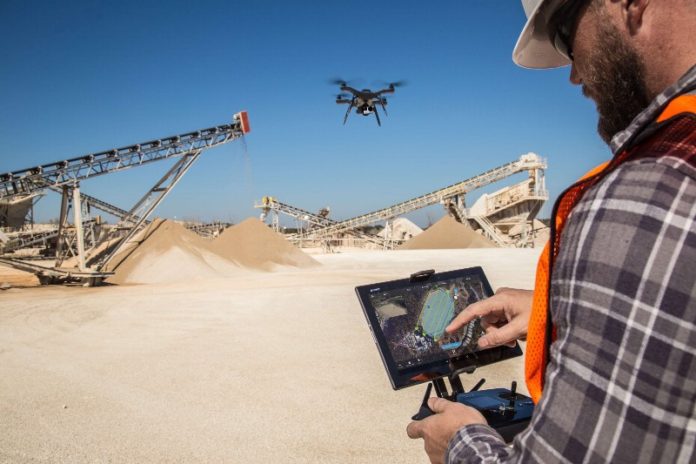
Drones seem to have the potential to revolutionize many areas of our lives, but today the biggest glitch is in mapping. These small flying machines can measure any area or object, even areas that were previously spent for days, in just a few hours. In this industry, accuracy is the most important thing. And if you can’t identify and deliver it, you can’t offer your customers anything other than a nice picture like the one above. Now let’s take a look at these details together.Ölçme Hassasiyeti ve Piksel Boyutu
One of the most important parameters of the measurement process is the spatial resolution, which is defined as “Ground Sampling Distance” in terms of photogrammetry. In the literature, it is defined as the distance between two consecutive pixel centers measured on the ground.
In practice, it is the size of the pixel in the area. SGD depends on the camera’s parameters (mainly camera resolution and focal length) and flight height. For example, using a hobby device to achieve a pixel size of 1 cm (3 inches), you need to fly at a height of 25 m, while using a more professional device allows you to achieve 1 cm GSD at 60m.
However, if you manage to complete your flight at 1 cm2 (0.16 inch2), the accuracy of the overall measurement (or, more precisely, the output of the measurement: Orthophotomap, Digital Surface Model, or 3D dotted cloud) is also 1 cm.
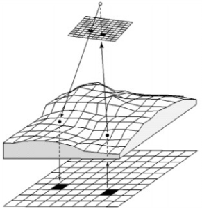 In photogrammetry, accuracy always depends on positional accuracy; this is defined as the degree to which the information generated on the map matches the real world from the data obtained.
Devices can create a correct photogrammetric model using software. However, fitting it to a correct geodetic coordinate system is a completely different task. Drones are equipped with GPS units that allow you to combine images neatly and create 3D models. However, this equipment is typically not accurate enough to put that model exactly where it should be with centimeter accuracy.
To better understand this, you can measure the distance between two points in your reconstructed model and see that the value is quite close to the measured value on the field. A close examination, however, revealed that the dots could be 1 meter away from their actual location on Earth!
What is Accuracy?
Accuracy can be interpreted in two ways: relative and absolute. Relative accuracy is a measure of how objects are positioned relative to each other in a reconstructed model (Orthophotomap, Digital Surface Model, or 3D point cloud). Absolute accuracy is the difference between the position of objects on the reconstructed model and its actual position on Earth (or geodesic coordinate system).
In most small areas, the relative model does good work. It allows you to measure distances, volumes, and height differences, and to perform actions such as applying vegetation indexes to your data. However, if you need to create a professional photogrammetric documentation or merge your data with other layers of data (for example, GIS vector data), or do any operation with geographic coordinates in a geodesic reference system, you must orient it using the so-called absolute Reconfigured model’s Location Checkpoints or Visual markers. These points should be measured using professional precision equipment such as RTK GPS or Total Station.
Accuracy Tolerances
When it comes to relative accuracy, the literature says you expect an error of 1-3 times the pixel size, both horizontally and vertically, for a neatly reconstructed model. This means that for a 2 cm GSD, it can reach accuracy in the range of 2-6 cm. Note, however, that this error is not general. It may be larger on a terrain with irregular heights or on a terrain without a characteristic object that makes it difficult to create a mosaic (eg forest, desert and water) when determining the anchor points. With absolute accuracy, the literature says that 1-2 GSD expects an error for the model to be reconstructed horizontally and 1-3 GSD vertically correctly.
It is good practice to measure a few other control points in the field as well as Ground Control Points. Control points allow you to calculate the accuracy of the model using normal measurement calculation methods. The resolution and accuracy should not be lower than required, but higher. A 1 km2 survey with a resolution of 1 cm2 produces over 180 GB of raw data that must be processed and stored and delivered to the customer. 2 cm resolution generates 4 times less data (up to 45 GB) and requires 4 times less resources for processing and storage. Therefore, from an economic perspective, it is very important to understand the conditions and, where necessary, to exceed the resolution and accuracy. We hope this article will help you understand the drone data accuracy and help you avoid common problems.
Stay tuned for more articles about drone mapping!


1 Comment. Leave new
Hi, it would be very useful to comment on the distances and distribution of the geodetic support points for areas of different extensions, thanks
Greetings