The importance of the concept of Geographic Information System is being understood more and more and is being used effectively by both public and private sectors in many different application areas. In order to discuss GIS policies, applications, technologies and generate ideas on these issues, GIS congresses of Turkish Chambers of Engineers and Architects (TMMOB), organized by the Chamber of Surveying and Cadastre Engineers (TMMOB), are organized every two years since 2007. The sixth CBS Congress will be held in Ankara from October 23rd to October 25th. Let us look at the importance of this congress and why you should attend.
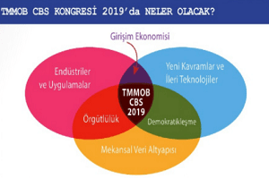
The aim of the GIS Congress is to increase the interaction of GIS concept with the society: to emphasize the importance of the use of spatial data / information and spatial information technologies at different scales in the world, To explain how the GIS approach can be used as a tool in the study subjects of 24 connected to TMMOB, to strengthen and develop the relations between the application subjects and GIS technology. to increase social, social and economic values by using spatial information and technologies and to enlarge the spatial information / information industry vertically and to expand horizontally. Producing a Map of TMMOB Interoperability Through GIS Concept: Using spatial data / information in TMMOB, using spatial information at different scales and resolution, Developing a sustainable communication platform among its developers and developing the interoperability model through this platform. Instead of sharing their ideas in GIS congresses held only once every two years, the 24 rooms in TMMOB through the said interoperability platform are aimed at keeping communication between the two congresses continuously and how to create more social and economic value in spatial intersections of the 24 rooms.
One of the objectives of the Congress is; To explain how the GIS approach can be used as a tool in the study areas of 24 rooms connected to TMMOB, to strengthen and improve the relations between GIS technology and application issues.
Coordination through GIS: Democratic mass organizations within the scope of TMMOB use spatial data, information and technologies either directly or indirectly in their professional practice areas. By using a spatial data infrastructure that will be established with an open data approach, workflows can be created with a solidarity approach and all rooms will be able to offer more environmentally friendly, low cost, sustainable and sustainable solutions to problems of different scales. If GIS projects developed for different areas and applications can be established using the same spatial data infrastructure and the use of GIS services developed by different chambers together will create greater social and economic values. The fact that the chambers of TMMOB are able to create intersections and produce joint works through spatial information in their fields of activity will contribute greatly to the development of TMMOB organization.
2. Should Attend Who CBS Congress? Alone GIS Congress is a Chamber event Geomatics / Surveyor Not all members are showing interest in the 24-room connected to tmmob’y, the Union of Bar Associations of Turkey except for the Chamber, other democratic mass organizations such as the Turkish Medical Association, trade unions, Turkey Informatics Foundation, non-governmental organizations, such as Turkey Informatics Association, academics, research institutions / centers, undergraduate and graduate students, corporate firms operating in different areas, local initiatives (startup), local governments, public institutions and organizations, end users, information such as citizens everyone who believes that they increase with sharing, who can contribute, who wants to expand their horizons, who needs motivation should participate.
3. What is not GIS Congress Although GIS Congress is an activity that presents many applications and projects suitable for its theme and focus, it is organized by hardware companies focused on spatial data production and / or software companies used in the evaluation, analysis and decision-support phase of spatial data. it is not an end-user conference. Similarly, it is not only a spatial information technologies fair where products and solutions of a particular company (s) are displayed.
4. What is the GIS Congress at that time? A wide range of public institutions, local governments, corporate firms, enterprises, non-governmental organizations, universities and research institutions, etc. It is an area where organizations effectively display new areas of application, concepts, technological orientations and innovation that are emerging in accordance with the theme and focus of the congress, creating an interaction, interaction and creating value-added or non-profit business opportunities. In all these respects, the GIS Congress is a high-level event, focusing on the development of policies on spatial information and technologies, and on the other hand developing ideas on how to generate geo-based solutions to problems in different areas of application. It also constructs business models on how new concepts and technologies can be used effectively with GIS technology. An approach showing the intellectual dimensions of the GIS Congress is shared as follows.
5. Why Should I Participate The issue of how to generate more value from GIS applications in the Spatial Information sector is more important when viewed from the window of the problem of employment and decrease in production that has started to be seen in almost all sectors. GIS Congress is an important tool in order to follow developments in the world of GIS, to develop business in this field and to establish cooperation. Spatial Information / IT industry, spatial intelligence community and GIS practitioners from all levels to search for solutions to global, national and local problems in a common platform and to establish collaborations towards this, to demand innovations in the production and use of spatial data / spatial information; Participation and contribution to the congress is important for everyone to show interest in the development of the opportunity to participate in this event, you want to express your thoughts on the topics and opportunities, different concepts to be inspired, you will interact with the new people will be absolutely.
Click for more information.
Source: Map Bulletin