Where classic surveying reaches its limits, the 3D photogrammetry application Agisoft Metashape Pro is being used, often in a combination with so-called ‘drones’ or Unmanned Aerial Systems (UAS). As part of the analysis and processing of geospatial data, Metashape Pro creates detailed, fully textured 3D models from digital recordings with the highest possible level of accuracy and detail. Metashape Pro is not only the ideal tool for working with UAS images, but also for big, large-format aerial cameras and terrestrial close-range pictures. Tens of thousands of users worldwide already benefit from this application’s level of detail and achievable precision. Together with the 3D PluraView monitors from Schneider Digital, such software technology extends to the quality 3D-stereo visualization. Thanks to their stereoscopic visualization quality, the 3D PluraView monitors from Schneider Digital open up the use of innovative 3D editing and measuring methods with the 3D Stealth Mouse S4-Z in Metashape for the first time! In combination, both high-end technologies together result in a 3D-STEREO workplace solution for geospatial data acquisition, processing and product generation at a high level. That is why the compatibility of Agisoft Matashape Pro with the entire 3D PluraView monitor product family has now been officially certified by the manufacturer Schneider Digital.
As a specialist in stereoscopic 3D hardware and visualization solutions with a global reach, Schneider Digital has been in close contact with the software company Agisoft for many years. Agisoft is considered one of the pioneers in the development of UAS and terrestrial photogrammetry solutions. From 2019 onwards, the company accelerated their functionality development for stereoscopic display and editing functions, due to rapidly growing customer demand. The 3D-stereo viewing and editing capability is especially important for UAS service providers for feature collection and in the creation and processing of dense 3D point clouds and textured building models.
Since the June 2020 release (1.6.3), Agisoft has been integrating a number of important 3D-stereo functionality in Metashape Pro to convert digital images into detailed, completely textured 3D models. Agisoft supports the stereoscopic editing functions of the Stealth 3D Mouse S4-Z in Metashape Pro, with the help of which it is now possible to work particularly precisely and efficiently in (holographic) space. While the standard version of Metashape is sufficient for basic, non-geodetic requirements and smaller projects, the Pro version is very well suited to create extensive, georeferenced 3D GIS datasets, enabling also interactive stereoscopic digitization. With the Pro version, up to 50,000 images of a physical object or geographical area can be integrated and processed in a coherent image block. The rigid 3D bundle block adjustment enables tens of thousands of users of Metashape Pro to solve 3D reconstruction, visualization, surveying, and mapping tasks efficiently and with high precision.
Due to its achievable accuracy, the software is used for UAS and aerial image triangulation, as well as for the processing of satellite images. Metashape Pro is also handling the creation of elevation models and processes terrestrial laser-scanning data, where objects are directly mapped and reconstructed with dense and precise 3D point clouds. At the heart of Metashape Pro are computationally intensive and precise reconstruction algorithms for the three-dimensional calculation and display of georeferenced objects, originally captured as densely matched surfaces by image sensors and as point clouds, originating from professional LiDAR equipment.
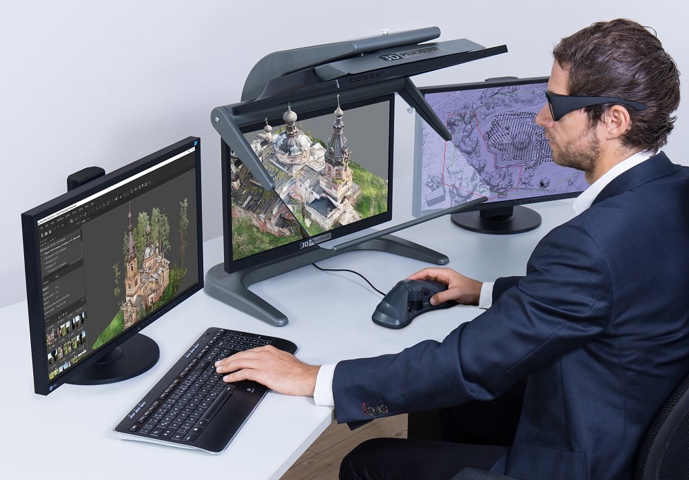
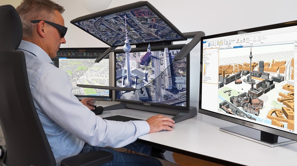
Metashape Pro is one of the most comprehensive photogrammetric software applications existing today. However, only in combination with high-performance hardware components, the real-time measurement, visualization and analysis of 3D datasets can be performed efficiently and true to reality. Key functionality elements are stereoscopic visualization, 3D feature capture and connectivity to very large GIS databases. With the dual-screen 3D PluraView displays, Schneider Digital provides a desktop solution for stereoscopic viewing and data editing. With display sizes up to 28” and 4K resolution per screen, the passive beam-splitter technology provides a daylight-usable, bright and, contrast-rich display of high-resolution GIS and BIM datasets.
Agisoft Metashape Pro allows for the reliable and precise processing of very large datasets and has become an indispensable part of workflow processes for many geospatial experts. UAS systems today may capture image series with several thousand images and resolutions reaching 1cm and less. In terrestrial close-range imaging even less than 1mm pixel size is achievable. Terabyte-sized datasets can be calculated with Metashape Pro and the right processing hardware without any problems. The capability to process large datasets with the ultra-high resolution is routinely used in the digital reconstruction of buildings and terrain models. A notable application being archaeology when recording and reconstructing cultural sites and assets.
With Metashape Pro, 3D models can also be recorded multiple times and displayed as a 4D time series. Due to its ability to realistically display geospatial background data together with highly detailed building models, Metashape Pro is also the ideal software for surveyors and architects. The main functionalities of this software solution are:
For the past 16 years, the passive beamsplitter monitor technology of the 3D PluraView monitors, especially in the geographic information industry, has been the reference with the high user satisfaction and user acceptance among all stereoscopic display systems.
As a further developed successor to the beamsplitter monitors from PLANAR, very large amounts of data can be spatially visualized in the high resolution with up to 4K / UHD per stereo channel. Especially on the 4K displays, the image quality that even finely textured objects are being displayed is sharp and rich in contrast, down to the small details. At the same time, the passive 3D PluraView monitors are durable and reliable. They deliver the substantial benefit of being able to work fatigue-free in all 3D stereo applications, even in normal office daylight conditions. Due to the passive 90° linear polarization filter glasses, which require a screen each for the left and right stereo image, the 3D PluraView monitors are flicker-free and independent of the room’s light source.
All of the 3D PluraView models are ‘plug & play’ compatible with the software application Metashape Pro. These 3D displays support professional software applications with high refresh and smooth image motion, combined with high colour depth and contrast. The 3D PluraView technology from Schneider Digital is the basis for precise, stereoscopic display capabilities of high quality. As a stereo-capable software solution, Agisoft Metashape always utilizes the full performance potential of each workstation: All components, i.e., multi-core CPUs, graphic cards and RAM memory are used optimally, in order to fully exploit and scale-up the performance of Metashape. Schneider Digital is also a specialized manufacturer of powerful high-end PULSARON workstations, based on AMD and the CENTURON series, based on Intel CPUs, both equipped with professional graphic cards from NVIDIA or AMD. These custom-built workstations are built to meet the individual requirements of the expert user and are optimally supporting Metashape in all processing tasks. Supplemented by special 3D hand-held controllers, such as the Stealth S4-Z or the 3Dconnexion SpaceMouse, complete processing environments are created by Schneider Digital with matching hardware components for computation, visualization, analysis and interaction with demanding, graphics-intensive 3D projects. Agisoft users benefit from a complete workplace solution by Schneider Digital, which guarantees high workstation performance and provides an optimal stereoscopic image visualization and editing environment. This combination and the compatibility of the Agisoft Metashape Pro software with the 3D PluraView monitors has now been officially certified by Schneider Digital.
How the interaction of Metashape Pro and the 3D PluraView monitor turns out in practice was successfully tested by Schneider Digital and Agisoft last year. As expected, both hardware and software met the high requirements of international standards in terms of quality and performance. The solutions have consequently been certified by both partners. For Josef Schneider, CEO of Schneider Digital, an important step forward: “We are delighted to be merging geospatial software and hardware into a high-performance combination through our collaboration with Agisoft. With the 3D PluraView monitor technology, we offer Metashape Pro users an ideal, truly spatial 3D visualization environment that enables them to experience Metashape 3D datasets individually or as a team in 3D-stereo. And this without having to wear restricting VR headsets.”
Further information is available at www.schneider-digital.com and www.3d-pluraview.com.