

Lake Eymir, located on the METU campus, is home to many plant species and species. The METU Birdwatching Group, which is composed of METU students and volunteers, is also investigating the diversity of plants, butterflies, mammals and birds in the region, documenting them and conducting studies to protect the ecosystem.
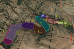
İbrahim Kaan Özgencil is a member director of METU Bird Watching Society responsible for education and scientific research and a PhD student in METU Biological Sciences Department. The aim of the project is to investigate and document the biodiversity aspects of the Eymir Lake region, which is part of the METU campus, and determine the priority areas for conservation and to plan the use of the people according to the information obtained. Within this scope, teams of METU students and volunteers investigate and document the diversity of plants, butterflies, mammals and birds in the region. The purpose of the community is to visit every corner of the Eymir Lake region every month of the year and to determine and estimate the bird species and population sizes in and around the lake. To determine where birds are concentrated and especially where conservation priority species are found. They try to relate the patterns and biodiversity patterns that they observe with some physical and biological characteristics of the sub-regions they work in and try to find out the physical, biological and human origin elements that may have an impact on the distribution of birds in the area. As a result of the project, they aim to determine the priority areas of protection for birds.

When the METU Bird Watching Society first set out, they did not have any analysis platform in their hands, collecting bird censuses with paper forms and then carrying out studies to digitize them. This process is both time they need to feel included in the Geographical Information Systems team to the Esri ArcGIS platform acquainted with Turkey for business processes that result in the loss of both sources. They use the ArcGIS Platform to collect data from the site, stream data from Eymir Lake Visitors, and perform analyzes around the lake. ArcGIS aims to determine the factors affecting the distribution and population size of bird species in the Eymir Lake region.

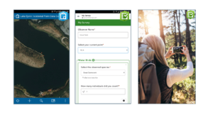
METU Bird Watching Society received their first bird observation analysis instantly with CollectorforArcGIS from the field with mobile application. All the data collected was transferred to the ArcGIS platform without any additional processing. Thus, the paper forms were saved from the loss of time during the digitization.
Lake Eymir is frequently visited by the people of Ankara, as it is a touristic region, there are nature lovers interested in bird watching. METU Bird Watching Society started using Survey123 forArcGIS in the data collection process and enabled the public to enter data.
The community used the analysis capabilities of ArcGIS to determine the physical and biological properties of the study areas.
The Group aims to contribute to the conservation planning of the area by combining its findings with the teams working with other living groups at the end of the Eymir Lake project. With the scientific articles and reports to be created as a result of this study, it tries to draw attention to the necessity to take more concrete steps in the protection of school lands and the plants and other species.
You can watch the video of the METU Birdwatching Society from the link below.