GIS & Mapping
Your source for all things GIS and Mapping, including breaking news, updates, guides, tactics, tips, trends, equipments, softwares and more!
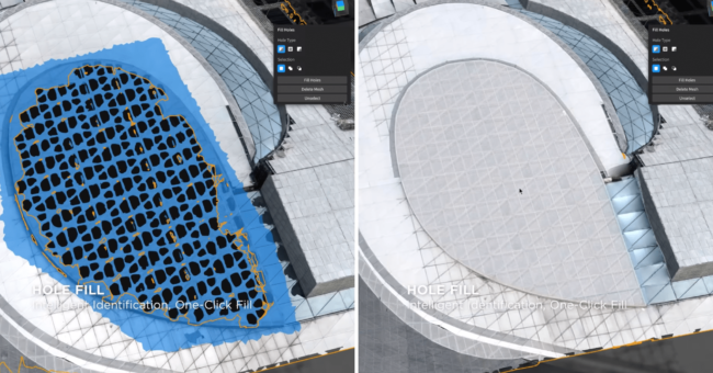
DJI Modify, The New Intelligent 3D Model Editing S…
By
DJI has just announced their first intelligent 3d model editing software. DJI Modify has amazing features that you will love.…
3 min read
884 reads

Grab’s Next-Generation Map-Making Camera “Ka…
By
Do you know how many tiny streets are there in an Asian Country? Yes, maybe more than millions:) Well, how…
3 min read
1K reads
AI Helped to Analyzed 2000 Terabytes Satellite Ima…
By
Breakthroughs in AI and satellite imaging have empowered researchers to generate the most detailed depiction to date of human activities…
4 min read
1K reads

EUSI and Pixxel’s Pioneering Hyperspectral I…
By
Introduction to the Strategic Alliance European Space Imaging (EUSI) has recently announced a pivotal partnership with Pixxel, granting direct access…
2 min read
1K reads

Vexcel Imaging Unveils Game-Changing Aerial Mappin…
By
Vexcel Imaging is raising the bar in airborne photogrammetry by introducing two groundbreaking aerial mapping systems: UltraCam Dragon 4.1 and…
2 min read
1K reads

Leica Geosystems BLK2GO PULSE: The Future of Mobil…
By
The BLK2GO PULSE is a new first-person laser scanner that combines cutting-edge LiDAR sensor technology with the original Leica BLK2GO…