Every mapping project is unique; even within the same industry, each project will have its own distinct challenges. Therefore, choosing the right equipment is the first but the most important stage of the job. Unmanned Aerial Vehicles (UAV) has emerged as a solution for many Mapping and R&D projects. However, we have addressed five important points that should be taken into consideration when deciding which type of UAV is best suited for your project in this technology, which still has more questions about its use.
With the development of technology, information acquisition is mostly realized on digital platforms. With the continuous renewal of science itself in Map Production, Map Making, which was previously produced with classical measurements due to reasons of time, economy and high accuracy, is rapidly advancing to leave its place to Unmanned Aerial Vehicles. Unmanned Aerial Vehicles is a high-tech startup that designs and manufactures reliable weather observation and data collection solutions for professional users. Unmanned Air Vehicles, Engineering projects (Highway, Rail Systems, Dam, Pond, HEPP, WEP etc.) studies, construction, mining, precision agriculture, forestry and other Map Making studies (Land Consolidation, Cadastre, Zoning Applications, Current Map, Orthophoto etc.) are used with cm level accuracy.
Unmanned Aerial Vehicles show us that it has a Map Making System designed not only to fly, but also to accelerate the entire workflow in our base created on Engineering Projects. Using time-efficient data collection allows users to have more projects to analyze real information and improve work schedule.
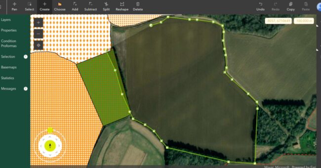
Mapping studies with unmanned aerial vehicles consist of four simple steps.
(i) Firstly, a flight plan is created based on the required accuracy and the designated project area.
(ii) Secondly, by pressing a simple button on the control unit of the Dron, the flight mode is switched to and data collection is started.
(iii) Third, data collected by UAV is processed by means of relevant image processing software.
(iv) Fourthly and finally, the data we process is provided to be analyzed in detail by Map specialists.
There are three types of UAV; Traditionally, a UAV consisted of two categories, the multicopter, and the fixed-wing. Today, a new drone is used as a hybrid.
(i) The Multicopter has flight features that are best compared to a helicopter and generally have four or more rotors.
(ii) Fixed Wing drones have features similar to traditional aircraft and can fly fast and long.
(iii) Finally, the hybrid drone is a cross product between the multicopter and the fixed-wing. In addition to the vertical take-off and landing capabilities of helicopters, there is a fixed-wing with efficient navigation of traditional aircraft. However, properly designed hybrids offer good performance, stability, and safety at all flight stages.
1- It is necessary to find a suitable place during Takeoff and Landing in Unmanned Aerial Vehicles. Since multicopters and hybrids can take off like helicopters, they only need a narrow and small area of at least 2 x 2 meters to maneuver. They are very flexible during the flight. When using fixed-wing drones, finding a suitable location can be difficult because they need a large, flat and open area for the terrain. Even then, the landing method, which we can call “navel landing”, regularly damages the aircraft body.
“If your project does not have large, open and grassy areas, the drone should have the ability to land and take off vertically flexibly. In other words, a multicopter or hybrid drone should be used. ”
“Fixed-wing and hybrid aircraft can fly faster, longer and with superior range. This makes them more effective in any Map Making project. ”
2- Due to the size of the area to be mapped and the height difference of the topography, it is necessary to consider it.
The size of the area has a direct correlation with the time required to cover the area and therefore with flight costs.
The rotating propellers of the multicopters use a lot of energy to stay in the air, so the multicopters have short-term durability by themselves and are very effective for small areas. In contrast, fixed-wing and hybrid aircraft use the aerodynamic shape of their wings to stay in the air. This allows them to fly faster, higher and in a longer range. Thus, it is made effective and efficient in every Map Making project, large or small.
“In general, fixed-wing drones can generate maps ten times faster than multicopters or helicopters.”
3- The fact that the ground is swamp and cliff or that we have to fly in the region rich in vegetation shows that being accessible to the Project area is an important factor.
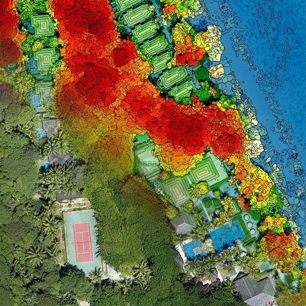
It is an inevitable reality for us to achieve a high level of visuality and absolute accuracy for such projects. It is often impossible to use a Ground Control Point in areas that are partially difficult or inaccessible to access. For the solution of such problems, PostProcess Kinematic (PPK) module integrated drones are needed. Similar to Real-Time Kinematics-Real Time Kinematic (RTK), this module produces the coordinates of the photos with much higher precision. The increased accuracy of the Horizontal and Vertical coordinates significantly increases the accuracy of the resulting Digital Surface Model. Thus, Mapping can be performed in areas that do not have access without the need for a Ground Control Point. Using the GCP only for regions with access will be sufficient for the integrity of the project.
4 – In order to obtain a high level of efficiency from the equipment used during Mapping, the drone should not bring an extra difficulty to the user during the transportation of the drone from one place to another in repeated flights.
Depending on the project, a selection of equipment should be made that this site should be suitable for transportation in air transport, it can easily fit in the small car used and that it will not be difficult to carry on site.
The best option is to use a hard carrying case designed to withstand air transport and also fit a small vehicle. It can be used as a durable Backpack carrying system for transport to nearby areas.
5 – Wind resistance is an important factor for drones to ensure that a project is delivered on time. It should be possible to bring the drone to the desired position during the flight and Wind Resistance should not prevent this.
A system with a higher Wind Resistance can allow more frequent flights, which allows users to complete the project on time.
Many propellers have good wind resistance during take-off. Because it provides a constant take-off and landing condition in windy weather with four propellers. However, due to the low speed of the multicopterin, which is in motion, performance decreases in heavy winds and durability is further reduced.
Fixed-wing Unmanned Aerial Vehicles have high speeds when driving. This allows them to fly very easily against the wind. It is likely that the problem will be encountered when conventional fixed-wing drones need to be launched and landed in windy weather conditions.
It can be suggested to use Hybrid drones as a solution for use in your projects. Because a hybrid drone with high wind resistance in landing and takeoff throughout the flight also has high wind resistance during cruise due to its fixed wings and high cruise speed.
“Hybrid drones equipped with at least four propellers have high wind resistance and stability during takeoff and landing, like multicopters.”
If you have a project that you think is difficult during Mapping and you plan to get the results using a drone, it is useful to know which type of drone is best for you. You can realize all kinds of projects visually from the air. But the important thing is that the results can be in the absolute accuracy desired and you can continue your work according to your purpose.
Source: GIM International